The “Northern” edition of the TGPCHPCMY2KMR starts in Fort Bragg, California and proceeds northward on CA1 and continues through northern California, Oregon and Washington on US101 which, historically, has also been considered part of the Pacific Coast Highway. This edition has historically alternated on even numbered years with the Sierra edition: 2006, 2010.
We will fine tune the itinerary as the ride gets closer. Please check back in late 2020 for a link to register for the ride so that I can keep you updated on the latest. And please sign the waiver.
Ride Bulletins:
- People must make their own reservations for motels and campgrounds. We suggest you do it two or three months prior to the ride, or sooner, to insure that accommodations are available. Links to each city we will be stopping in along the way and to a list of accommodations available in those cities can be found below.
- We will have get-together dinners every night of the ride and one luncheon; see the dinner signup sheet on this web site for details – please signup so we can tell the restaurants what to expect.
- We will try to get a group photograph of as many of the riders and their bikes as possible at Mac Kerricher Park north of Fort Bragg on Monday morning before we start out. Please try to be there about 9:00AM.
- TBD
- TBD
- TBD
Itinerary:
September [TBD] (Saturday and Sunday): Gather in Fort Bragg
- Most popular motel for riders in the past: ** Best Western Vista Manor Lodge, 1100 N. Main St., 800 821-9498
- Gather for dinner Saturday at Cliff House of Fort Bragg , 1011 South Main Street, (707) 961-0255
- Gather for dinner Sunday at The Wharf Restaurant ,32260 North Harbor Drive, (707) 964-4283
- Featured side ride: Leave 10AM Sunday; CA20E to Willits; US101S past Ukiah; CA253W to Boonville; CA, stop for lunch at the Redwood Drive-In in Boonville, continue on 128W to CA1; CA1N through Mendocino to Fort Bragg – 128 miles
- Fort Bragg lodging, restaurants and attractions

From Fort Bragg take CA1S to the junction with CA20; CA20E to Willits; take US101S through Ukiah to the junction with CA253; take CA253W to Boonville; take CA128W to CA1; take CA1N through Mendocino to Fort Bragg.
September [TBD] (Monday): Leave Fort Bragg, CA 9:00 AM
- Gather at MacKerricher Park north of Fort Bragg for group and bike photos at 9:00AM
- Head north on CA1
- At Leggett, CA turn right through town and head for the drive thru tree. When finished, go back thru Leggett, turn right and then turn left (north) on US101.
- Exit at Garberville
- Gas stop at Garberville – the first and last one for a while.
- Lunch at Garberville; we will stop at House of Burgess, on the left.
- After lunch, proceed north on US101 until you see the signs for Avenue of the Giants (CA254) near Phillipsville.
- (This is the FIRST exit for the Avenue of the Giants)
- Exit onto the Avenue of the Giants (CA254) and stay on it until the junction with CA211 about 2 miles past Weott.
- At the junction with CA211 turn left toward Honeydew, CA; this is the Lost Coast route.
- Proceed west and north through the redwoods along the Lost Coast route through Honeydew and Petrolia; rest stop at Honeydew
- Proceed through Ferndale, CA and back onto US101 north.
- Arrive Eureka, CA between 4 and 5PM.
- Distance: 180 miles (6-8 hours*)
- Most popular motel for riders in the past: ** Motel 6, Broadway between Del Norte & Hawthorne, 800 466-8356
- Time for side trips, etc.
- Suggested side ride #1: US101N to CA299; CA299E to Burnt Ranch and back – 122 miles
- Gather for dinner, Woodley Island, Cafe Marina (select Eureka),601 Startare Drive, (707) 443-2233
- Eureka lodging, restaurants and attractions

From Fort Bragg take CA1 north to the junction with US101 at Leggett. Continue north on US101 until you reach the Garberville exit. Exit into Garberville for lunch and gas, if you need it. From Garberville, get back onto US101 north. Continue on to the first exit for Avenue of the Giants (at Phillipsville). Exit onto Avenue of the Giants (CA254). Continue going north on that route until the junction with CA211/Mattole Road. That junction occurs as you come out of the redwoods and cross a bridge where the freeway is going overhead. Turn left at the end of the bridge onto CA211/Mattole Road. Signs should point to Honeydew and/or Petrolia. Continue west on CA211 to Honeydew. Rest and potty break there; no gas is available. Continue north and west on CA211 through Petrolia to Ferndale. When you come down into Ferndale, you will pass through a gate, turn right and a block later turn left onto Ferndale’s main street. Continue on through Ferndale until you cross the river. At the stop sign, turn left and follow the signs for US101 north and Eureka. Stay on US101 north until you reach Eureka.


As you come out of the redwoods on Avenue of the Giants, go across the bridge and turn left and go under the freeway. You are now on Mattole Road/CA211 heading for Honeydew and Petrolia.
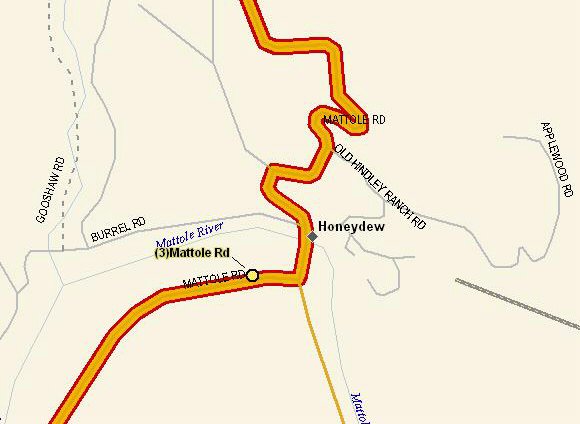
Immediately after crossing the WOODEN bridge at Honeydew, turn right and stop at the Honeydew store. Take it easy crossing this bridge and stay on one of the longitudinal tracks.


September [TBD] (Tuesday): Leave Eureka, CA 9:00 AM
- Head north on US101
- Enjoy the scenery
- Stop for lunch at Beachcomber Restaurant, 800 Chetco Ave., Brookings, OR
- Side trip to Cape Blanco lighthouse
- Proceed to Coos Bay, OR
- Arrive in Coos Bay between 4 and 5 PM
- Suggested motel: Motel 6; 1445 Bayshore Drive, (541) 267-7171.
- Distance: 230 miles (7-9 hours*)
- Time for side trips, exploring, etc.
- Gather for dinner at Benetti’s Italian Restaurant, 260 S. Broadway, Coos Bay, OR, 541 267-6066
- Coos Bay lodging, restaurants and attractions
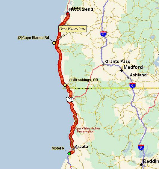
side jaunt to Cape Blanco lighthouse.

September [TBD] (Wednesday): Leave Coos Bay, OR 9:00 AM
- Head north on US101
- Enjoy the scenery
- Stop for lunch in Newport, OR at Mo’s Restaurant, 657 SW Bay Blvd.; 541 265-7512
- Side route to Cape Kiwanda, Cape Lookout and Cape Meares on the way to Tillamook
- Stop at Tillamook County Creamery Association, 2 miles north of Tillamook on US101 to tour the cheese factory OR
- Proceed south from Tillamook on US101 and stop at the Tillamook Air Museum; admission $10.50 ($9.50 for us old farts)
- Proceed to Seaside, OR; arrive between 5 and 6PM
- Suggested motel: Motel 6, 2369 S. Roosevelt Drive, (503) 738-6269
- Distance: 237 miles (7-9 hours*)
- Time for side trips, sightseeing, etc.
- Gather for dinner at Bigfoot’s Pub n’ Grub, 2427 S. Roosevelt, Seaside, OR; 503 738-7009 (next door to Motel 6)
- Suggested side ride #1: ?
- Seaside lodging, restaurants and attractions

Proceed north on US101. Continue on until Newport where we stop for lunch.
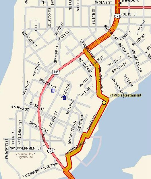
At Newport, turn right at Waterline Drive (just after the bridge), right again at Bay Street and left on Bay Blvd. Continue on to Mo’s Restaurant and lunch. After lunch continue north on Bay Blvd., turn left on Fall Street and right on Canyon Way. Jog left onto Hurbert Street and after about 2 blocks, turn right onto US101.

Turn left on Brooten Road toward Pacific City, OR.
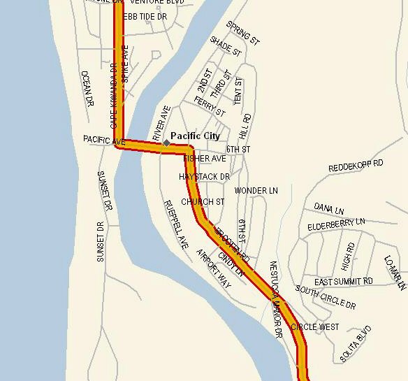
In Pacific City, turn left on Pacific Avenue and right on Cape Kiwanda Drive which eventually becomes Sand Lake Road.
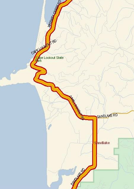
At the junction of Sand Lake Road and Cape Lookout Road, turn left onto Cape Lookout Road.

Cape Lookout Road eventually becomes Whiskey Creek Road. Turn left off Whiskey Creek Road onto Old Netarts Highway West.
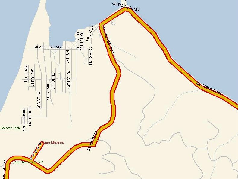
This road changes names to Happy Camp Road and then to Bayshore Drive and then to Cape Meares Loop. We turn right onto Bay Ocean Road at the point where we run out of road…
Continue on Bay Ocean Road until it deadends at a T-joint with McKinley Moorage Road. Turn left onto McKinley Moorage Road which quickly becomes Third Street. Continue on Third Street until the junction with US101. Turn left onto US101 north. We are now in Tillamook. About 2 miles north of Tillamook is the Tillamook County Creamery Association. We will be stopping for a tour and samples.
After leaving Tillamook, continue north on US101 until we reach Seaside.
September [TBD] (Thursday): Leave Seaside, OR 9:00AM
- Head north on US101
- Turn left on WA105 just north of Raymond, WA. Continue on WA105 to the turnoff for Tokeland, WA. Follow Tokeland Road to the signs for the Tokeland Hotel and Restaurant.
- Stop for lunch at the Tokeland Hotel and Restaurant, Tokeland, WA,
- After lunch, head north on Tokeland Road and onto WA105 and follow WA105 until it reconnects with US101 just south of Aberdeen, WA
- Proceed to Forks, WA; arrive between 5 and 6 PM
- Suggested motel: Pacific Inn Motel, 352 S. Forks Ave., 800-235-7344
- Distance: 207 miles (6-8 hours*)
- Time for sightseeing, side trips, etc.
- Gather for dinner at the Forks Coffee Shop, 241 S. Forks Ave., Forks, WA; 360 374-6769; about 2 blocks north of the motel
- Suggested side ride #1: Go north from Forks and turn left on WA110 to La Push, WA on the coast; 32 miles
- Forks lodging, restaurants and attractions

From Seaside, continue north on US101.
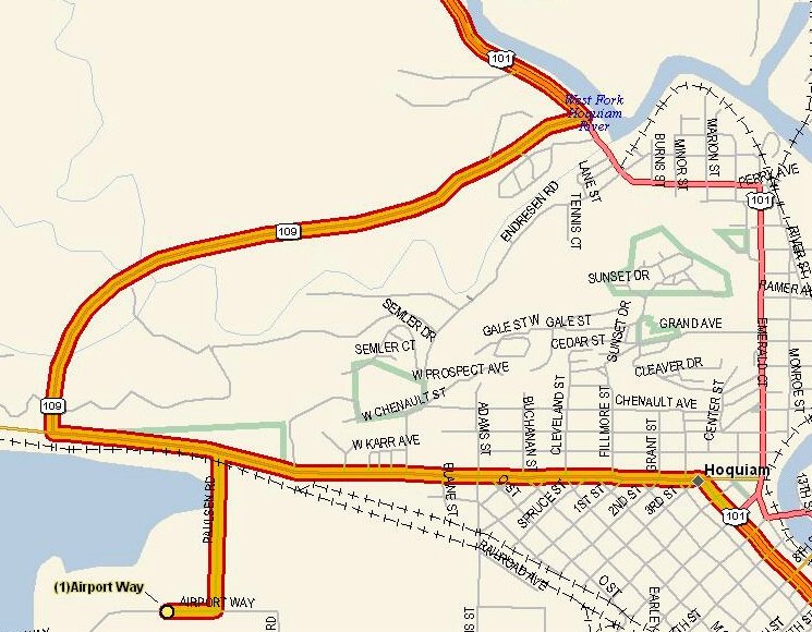
At Hoquiam, WA, we will be stopping for lunch. Turn left off US101 onto WA109. Continue on WA109 to Paulsen Road. Turn left on Paulsen Road. Turn right on Airport Way. Lunch at Lana’s Hangar Cafe.
After lunch get back onto Paulsen Road. Turn left on WA109 and take the scenic route back to US101. Turn left onto US101 and continue north to Forks, WA.
September [TBD] (Friday): Leave Forks, WA 9:00AM
- Head north on US101
- Ride past lovely Crescent Lake, to Port Angeles
- In Port Angeles, turn right on Race Street. Continue on Race Street and veer right on Hurricane Ridge Road. Ride up to Hurricane Ridge.
- At Discovery Bay, pull off into Fat Smitty’s for lunch.
- Proceed to Olympia/Tumwater, WA; arrive between 3 and 4 PM
- Suggested motel: Motel 6, 400 West Lee St., Tumwater, (360) 754-7320
- Distance: 213 miles (5-7 hours*)
- Time for sightseeing, side trips etc.
- Gather for dinner at El Sarape Mexican Restaurant, 5409 Capitol Blvd. S, Tumwater, WA; 360 956-9506.
- Suggested side ride #1: Turn right on Capitol Blvd and ride to Centralia, WA via Tenino, WA on old Hwy 99 and WA 507; 49 miles
- Olympia lodging, restaurants and attractions


From the junction of US101 and I5, take I5 SOUTH. Exit I5 at exit 102. At the end of the off ramp, turn left on Trosper Road SW. Cross the freeway and continue on to Capitol Blvd. S. Turn right on Capitol Blvd. S. and go south to Lee Street. Turn right on Lee St. SW and continue on to Motel 6.
September [TBD] (Saturday and Sunday):
- Gather for dinner at the Tides Tavern, 2925 Harborview Drive, Gig Harbor, WA; 253 858-3982
- Suggested side ride #1: Museum of Flight Trip; 128 miles
- Return home…
- Suggested side ride #2: Mt. Saint Helens trip; 244 miles

From Motel 6 in Tumwater, turn left on Lee Street and go to the first light which is Capitol Boulevard. Turn left again. Go to the first light which is Trosper Road. Turn left on Trosper Road and take an almost immediate right onto I5 North. Stay on I5 north until Exit 158, turn west, go under I5 and turn right on E. Marginal Way. The Museum of Flight is about a quarter mile north on the right side.
After leaving the Museum of Flight, continue north on Marginal Way. Turn left on 16th Ave S. Head south on 16th Ave S. until it becomes 14th Ave S. A couple of blocks later, you reach Cloverdale St. Turn right on Cloverdale St. Continue west on Cloverdale until it turns south and runs into 1st Ave SW. Veer right onto Olson Place. Veer right onto Cambridge St. Almost immediately, turn right onto 4th Ave. SW. Turn left on Cambridge St. Continue on Cambridge St. to Delridge Way. Veer right on Delridge Way and veer left onto Barton St. Continue on Barton St. to the ferry dock. Take the ferry to Southworth. Leave the ferry terminal and head west on Southworth Drive. Turn left on Washington 160. Stay on WA160 to the junction with WA16. Turn left on WA16. Exit off of WA16 onto Burnham Drive. Head south on Burnham Drive until it reaches Harborview Drive. Veer onto Harborview Drive and continue on to the Harbor Inn Restaurant.
After leaving the restaurant, head south on Harborview and veer right on Soundview Drive. Soundview Drive becomes Olympic Drive. Continue on Olympic Drive to the junction with WA16. Head south on WA16. Cross the Tacoma Narrows bridge (son of Galloping Gertie). Continue on WA16 to the junction with I5. Get on I5 and continue south to Exit 102, Trosper Road. Exit I5 and return to Motel 6.

From Motel 6 in Tumwater, turn left on Lee Street and go to the first light which is Capitol Boulevard. Turn left again. Stay on Capitol until you reach Custer Way. Turn right on Custer Way. Go one block to Cleveland Avenue. Turn right on Cleveland. Stay on Cleveland until it becomes Yelm Highway SE. Stay on Yelm Highway SE to the junction with WA510. Turn right on WA510 south. Stay on WA510 south until it joins with WA507 in Yelm. Stay on WA507 to the junction with WA702. Turn right on WA702. Stay on WA702 until the junction with WA7. Turn right on WA7. Stay on WA7 until the junction with US12 at Morton. Turn left on US12. Stay on US12 until the junction with WA131 in Randle. Turn right on WA131. Stay on WA131 until the junction with County Road 39 (Woods Creek Road). Turn left onto Woods Creek Road. Stay on Woods Creek Road until it runs into or becomes Forest Service Road 25. Turn right on FS25. Stay on FS25 until the junction with FS99. Turn right on FS99. Stay on FS 99 until the end of the road.
The above route is courtesy Bruce Pickett. Thanks, Bruce.
* – depending on how fast or how slow you take the curves.
** – these motels will take reservations through the web
What to expect on the ride…
In addition to a week of great motorcycling, wonderful camaraderie, a lot of nice people having a good time, lots of good food, lots of beautiful scenery, you can most likely expect the following during the ride:
Weather:
The weather will be cooler than the southern route. We may run into rain, possibly heavy at times. You must be prepared to dress for wet weather and for cool temperatures. The temperature range varied from about 90 degrees F inland to as low as 45-50 degrees F along the coast. A layered approach for clothing is strongly suggested.
Traffic:
The traffic on the northern route is somewhat heavier than on the southern route. It should be lighter than during the summer because it is after Labor day.
Road Conditions:
There was little construction encountered on the 2004 ride.
The Lost Coast section of the road between Eureka and Fort Bragg is a little rough and has some spots of packed gravel (the longest was not more than a few hundred feet).
The roads are very twisty and winding (yesssssss!!! – great for motorcycles!!) as far as Eureka. You need to bring your cornering skills with you and to take it easy if you think the road is getting to be too much for you. There is plenty of time to make our destinations at even a relatively slow pace. Don’t hurry! Take your time and enjoy! Above all, RIDE YOUR OWN RIDE AT YOUR OWN PACE. I can’t emphasize this strongly enough!
After Eureka, the road straightens considerably.
Motorcycle Dealers along the way:
- Ft. Bragg:
- Nearest Honda dealers: Ukiah and Lakeport (both are a considerable distance away)
- Motorsports of Ukiah, 724 S. State. St., Ukiah, 707 462-8653
- Hillside Honda, 460 S. Main St., Lakeport, 707 263-9000
- North Bay Honda, 28975 Santa Rosa Avenue, Santa Rosa, 707 542-5355
- Nearest Honda dealers: Ukiah and Lakeport (both are a considerable distance away)
- Eureka: Richard Miller Motorcycles, 1725 Tomlinson, Eureka, 707 443-8031; 1 block south of Bayshore Mall
- Redding:
Lee’s Honda, 2230 Larkspur Lane, Redding, 530 221-6788 - Coos Bay:
- Honda World, 1350 Ocean Way, Coos Bay, Oregon, 541 888-5588
- The Sportsman, 249 N Coast Hwy, Florence, Oregon, 541 997-3336
- Honda of Tillamook, 1000 N Main, #13, Tillamook, Oregon, 503 842-5593
- Seaside: (currently none)
- Forks: (currently none)
- Olympia:
- Port Angeles Power Equipment, 2624 E Hwy 101, Port Angeles, Washington, 360 452-4652
- South Sound Honda, 2115 Carriage Dr SW, Olympia, Wash, 360 357-9633
Questions:
If the preceding raises any questions, or if you have questions on anything else, please email me: Douglas Van Bossuyt